Mapping India
How an idea to tell the story of India’s history in a few maps grew into an exhibit of 100+ artifacts and a scholarly journey.
By Casey Brown
Photography by Kim Fetrow ’96 of Kim Fetrow Photography
Partition (verb): to divide (a place, such as a country) into two or more territorial units having separate political status.
In 1947, India was partitioned into India and Pakistan. An exhibition in the spring of 2023 at Whitman College’s Maxey Museum maps out the historical, political, social and geographical factors and forces at play: “Mapping India: Colonialism, Nationalism, and the Partition of South Asia.”
It was a coming together, not division, that culminated in this impressive showing of historical maps and other artifacts of the region.
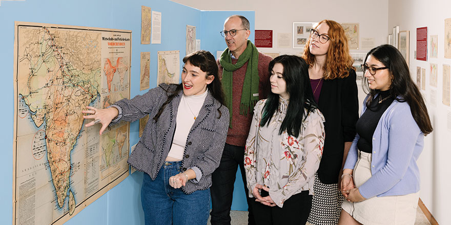
Associate Professor of Art History Krista Gulbransen spearheaded what was a four-year scholarly effort, working closely with student researchers to help her vision go from an abundance of materials to telling a story of imperialism and independence in South Asia on the museum walls.
Where did these maps and objects originate? They’re from a collection gathered from around the world by another scholar, Whitman alum Mark Giordano ’88.
Giordano, who was an Economics major at Whitman, earned his Ph.D. in Geological Sciences in 2002 from Oregon State University. Giordano is currently a Professor of Geography and Vice Dean for Undergraduate Affairs at the Walsh School of Foreign Service at Georgetown University in Washington, D.C.
Giordano recalls being encouraged by his Whitman gallery connections to meet Gulbransen after she joined Whitman’s faculty in 2014 as an art historian specializing in South Asian art and architecture. Their shared interest in the region’s artifacts was the first spark for the India collaboration.
Over months and years, Gulbransen, along with her student researchers—Amira Jain ’23, Alexa Pilgrim ’22, Connor Rauch and Issabella Zito ’23— and one of Giordano’s Georgetown students, Laetitia Haddad ’23, combed through and studied the extensive collection, mostly through high-resolution images and scans. It included over 200 artifacts—with more than 100 ending up in the exhibition.
“I trained the students in how to think about and research maps, gave them background information about colonial Indian history, and shared with them the central vision and goals of the show,” Gulbransen says.
In the work, she saw an opportunity to tell the complex story they were uncovering. The maps foreshadow and address the consequences of partition, among other topics.
“Drawing a line in the sand and saying ‘OK, these are two countries now’ brought mass migration and communal violence,” says Gulbransen.
The revealing results of the project impressed even the collection owner, whose original aim was to gather objects that could help convey the history of the region—something he and Gulbransen agreed was missing from American academia.
“I had an idea that if you had about eight to ten maps it would tell this story,” Giordano says.
In their research, Gulbransen and team delved deep into the history, culture and politics.
Giordano says,“There was a lot more that came out in the maps than the basic story.”
Meaningful Research & Lifelong Skills
For the students who helped Gulbransen research and curate the exhibit, the work was enlightening. And for one, it hit close to home: Jain was born in India. The Film and Media Studies major lived there until age 13, when she moved to California.
Jain says she got involved because she wanted to access art history in a new way—her previous experience was limited to studying paintings, sculptures and prints. As a native speaker who also reads and writes Hindi fluently, Jain was able to help with translation and the project provided an opportunity to talk with her own family more.
“If I didn’t know something, I’d send a picture to my grandpa,” she says.
Jain was also grateful to gain a deeper understanding of her birthplace.
“In India, I was taught the history of how the country was conceived in a very particular way. It was important for me to get an outside perspective about that and form my own unbiased opinion,” she says.
“I learned so many research skills,” Jain says. “It is one of those things that now that I have all these tools in my arsenal, how can I not use them?”
She also can look ahead to see what her life after Whitman might look like.
“It is cool that Whitman keeps in contact with alums. Mark works at a completely different school and has a commitment here (Whitman) and loaned us his entire collection,” Jain says.
Zito, an Art History major from Seattle, found the work compelling and says she has always been fascinated with maps.
“We wanted to convey that maps aren’t an objective scientific tool,” says Zito. “It isn’t a common topic to talk about the intricacies of the maps and how subjective they are to their personal viewpoints.
“We had to figure out what the maps were saying, what they were about, research who made them, where they are coming from and, if possible, why they were made.
“We distilled pages and pages of research about maps into something.”
The Exhibit—The Journey
The collection features rare pieces, such as one of the first maps ever printed on a printing press, one that orientates to the south rather than the north and a piece printed by the Luftwaffe (German Air Force) in World War II that showed potential locations for air raids.
As visitors walk toward the museum space, a massive map is displayed on the wall facing the exhibit. It shows the entire subcontinent without borders—while “the show is about how the borders came to be,” Gulbransen says.
The exhibition itself is partitioned into four sections.
Section I. Traveling and Trading: European Merchants in India.
To begin, museum visitors see how travel and trade affected the continent. Maps in this section include the “upside down map” from 1564 or 1565, which focuses on water and maritime trade, and a 1798 map made by the British trying to guess the route Napoleon would take if he tried to conquer India.
There are military maps, merchant maps from England’s East India Company, and pieces from the Dutch, Portuguese and French.
Section II. Seizing and Surveying: Territorial Expansion Under the British East India Company.
This section explores land surveys and seizures, largely by the East India Company. What was founded as a trading company became an imperial state exerting control over newly acquired territories, with maps used as a tool to seize the land.
“So many of the maps in this section were made by other nations as a way to conquer the land and its inhabitants for one reason or another,” says Gulbransen.
Section III. Ruling and Resisting: The Independence Movement Under the British Raj.
The third section explores the rise of resistance during a time when Queen Victoria of England was declared as the Empress of India.
During this period, the map, originally a colonial tool for control, becomes an important nationalist image used by folks to imagine an independent nation, Gulbransen says.
Over time, nationalist images, such as Mother India, or Bharat Mata, from the 1930-40s, were defined by Indian people themselves, rather than what was prescribed to them from other cultures. Items in this section include pieces that showcase Mahatma Gandhi, the Buddha and Hindu reform leader Swami Vivekananda. Each piece is related to what is known as the Independence Movement.
Section IV. Defining and Dividing: Post-Colonial Borders in South Asia.
The final section of the exhibit helps explain what led up to the partition and how the borders being drawn would eventually divide India into Pakistan and India.
Nationalist protests continued to grow throughout the first decades of the 20th century, culminating in 1942 with the Quit India Movement led by Mahatma Gandhi that demanded freedom from British rule. With limited resources after World War II, British Raj officials began to consider when and how to dissolve the colonial state in India.
This fourth section includes two maps from 1909 that visually depict religious groups. The first, titled “Prevailing Religions,” indicates the religious majority in each region, while the second, “Religions,” shows the distribution of Hindu, Muslim, Christian, Buddhist, Sikh and Jain communities across the subcontinent. These maps were used to draw the partition line.
According to Gulbransen, this complicated South Asian history has current repercussions—and offers local insights, as well.
“Border disputes cannot only be understood by looking at the present moment,” she says. “The politics today in India and Pakistan, there’s no way you can understand them without understanding the history of partition and colonialism.”
And while it is not the same story, the history of settler colonialism in and around Walla Walla has important thematic connections to her exhibition, Gulbransen says.
“I hope that the show raises some of these broader issues for people, encouraging them to think about the implications of drawing maps and labeling land.”
