Maximum Glaciation and Deglaciation History of
Clarks Fork Lobe of the Yellowstone Ice Sheet, Wyoming and Montana
Beth Bartel
Department of Geology Whitman College, Walla Walla, WA 99362
New data collected during the summer of 1997 in the drainage basin
of Clarks Fork of the Yellowstone River was synthesized with previous
data and ideas to complete a deglaciation history of Clarks Fork lobe
of the Yellowstone ice sheet. Data include ice flow indicators (striae,
grooves, and indicators) and evidence for upper ice limit (erratics
and landforms). The ice lobe was reconstructed at its maximum (total
glaciated area was 1390 km2), and surface contours were constructed.
ELAs (equilibrium line altitudes) calculated for various AARs (accumulation
area ratios) are: ELA 3025 m at 60% AAR, ELA 2950 m at 67% AAR, and
ELA 2875 m at 75% AAR. The lobe originated from four main ice bodies
within the Beartooth and Absaroka Mountains, which met in Clarks Fork
valley and flowed east through Clarks Fork Canyon, terminating as
a piedmont glacier in the Bighorn Basin. In the accumulation area,
ice was thinnest in the eastern Beartooth Mountains. In the ablation
area, ice flowed into and dammed valleys on the south side of Clarks
Fork valley, resulting in the formation of glacial lakes; ice was
as thick as 570 m in Clarks Fork Canyon. A radiocarbon date of approximately
26,000 calendar years has been attained for the Pinedale glacial maximum.
During deglaciation some of the lakes were sources of jkulhlaups.
Lack of extensive outwash indicates deglaciation was relatively rapid,
particularly in the eastern Beartooths, but dozens of moraines offer
evidence of numerous episodes of active retreat with ice at equilibrium.
Clarks Fork ice had retreated upvalley of the mouth of Crandall valley
while Crandall ice still extended into Clarks Fork valley. Clarks
Fork ice was still present in Clarks Fork valley past the mouth of
Pilot valley when Pilot ice retreated from Clarks Fork valley. At
least one jkulhlaup from upper Clarks Fork valley or from Pilot valley
at or near this ice position sent floodwater down Clarks Fork valley
at least to Ghost Creek, where it was diverted by Crandall ice and/or
disappeared into Clarks Fork Canyon. Deglaciation of central Clarks
Fork valley was complete by a minimum of 13,482 +/- 180 calendar yr
B.P. The ice divide at Colter Pass shifted eastward during deglaciation.
During final retreat of Clarks Fork ice, ice at this divide became
stagnant and meltwater deposited ice-contact stratified drift.
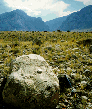 |
Terminal moraines. Colossal terminal moraines are found
at the mouth of the Clarks Fork Canyon, where Clarks Fork outlet
glacier spilled out into the Bighorn Basin. The glacier was confined
by Clarks Fork Canyon (background), then spread onto Bighorn Basin
as a piedmont glacier. Seen here are two of the multiple moraine
crests, with a boulder sampled for cosmogenic dating in the foreground. |
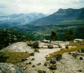 |
Clarks Fork - Crandall junction. Crandall valley opens
into Clarks Fork valley from the south (left of center). Ice
from Crandall valley occupied Clarks Fork valley at the Crandall
valley - Clarks Fork valley junction after ice from the Beartooths
had retreated upvalley. Erosional features such as the roche
moutonee (ice-sculpted bedrock knob) in the foreground are evidence
that the ice flowing from the Beartooths was warm-based. Bob
Carson indicates direction of ice flow in the valley with his
head. |
|