Radon Levels in Eastern Washington 16
| County (# of samples) | Mean Rn Level (pCi/L) | Standard Deviation | Percent Above 4 pCi/L | Percent Above 20 pCi/L |
|---|---|---|---|---|
| Adams (11) | 3.5 | +/- 4.4 | 18 | 0 |
| Asotin (18) | 2.9 | +/- 6.3 | 6 | 6 |
| Benton (106) | 1.8 | +/- 3.5 | 7 | 2 |
| Chelan (9) | 2.2 | +/- 2.2 | 11 | 0 |
| Columbia (5) | 3.4 | +/- 1.7 | 40 | 0 |
| Douglas (17) | 1.6 | +/- 1.3 | 0 | 0 |
| Ferry (28) | 3.2 | +/-3.9 | 25 | 0 |
| Franklin (26) | 1.6 | +/- 1.4 | 21 | 0 |
| Garfield (5) | 0.8 | +/- 0.7 | 0 | 0 |
| Grant (54) | 1.9 | +/- 2.9 | 9 | 0 |
| Kittatas (4) | 1.2 | +/- 0.7 | 0 | 0 |
| Klickitat (22) | 1.7 | +/- 2.3 | 14 | 0 |
| Lincoln (15) | 2.2 | +/- 1.6 | 7 | 0 |
| Okanogan (43) | 2.8 | +/- 3.7 | 21 | 0 |
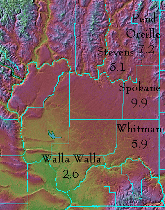
| Pend Oreille (55) | 7.2 | +/- 19.1 | 31 | 5 |
| Spokane (449) | 9.9 | +/- 14.2 | 59 | 13 |
| Stevens (47) | 5.1 | +/- 11.3 | 32 | 4 |
| Walla Walla (56) | 2.6 | +/-2.3 | 23 | 0 |
| Whitman (31) | 5.9 | +/- 14.0 | 39 | 3 |
| Yakima (134) | 1.8 | +/-2.5 | 6 | 0 |

Map of Eastern Washington, Courtesy of Ray Sterner (with some adaptations), Johns Hopkins University
Click on the map to see all of Washington State.
